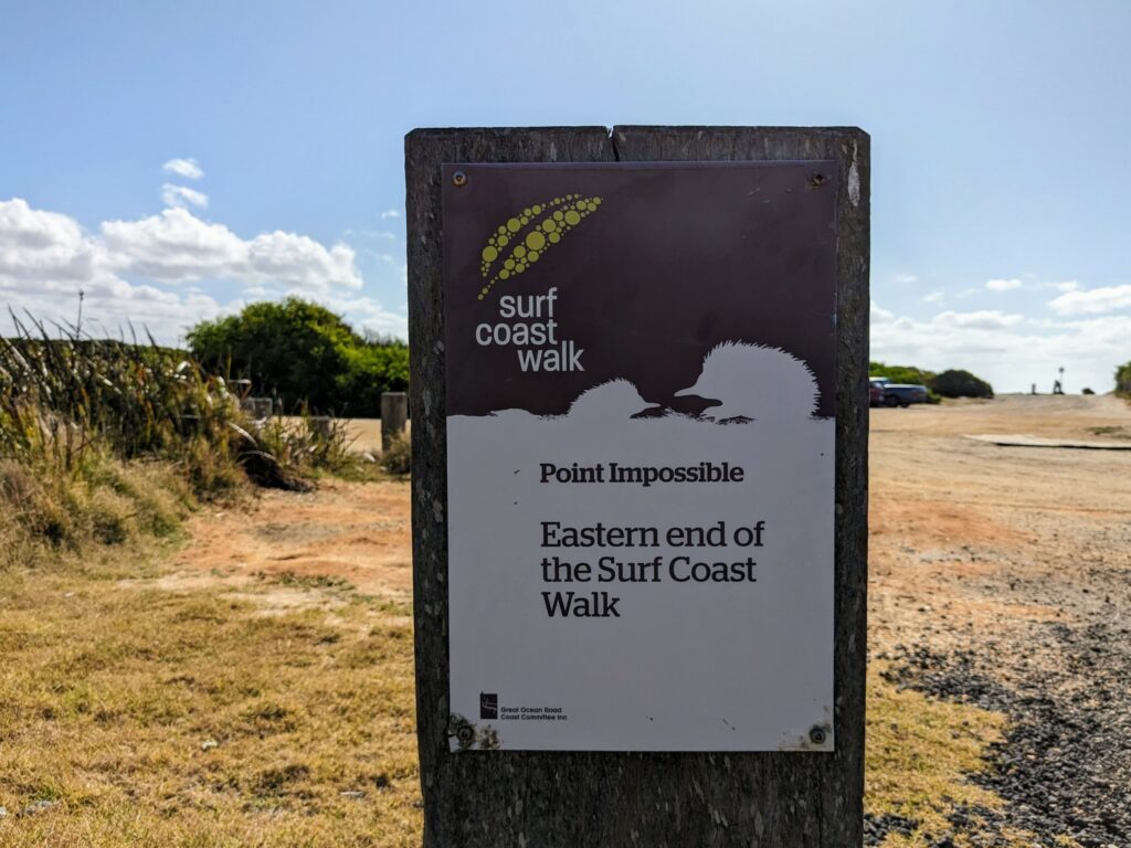
The Surf Coast Walk is a 44km path that runs from Point Impossible, a few kilometres east of Torquay, to Fairhaven, just west of Aireys Inlet. In perhaps unsurprising news, this part of Victoria is known as the Surf Coast, and the route hugs the shore most of the way.
Towering cliffs, roaring seas, and empty beaches are the main themes here, but there’s plenty of coastal bushland and sheltered forest to enjoy as well. The track regularly runs along the beach, but even where it doesn’t, you can often just drop down to the sand to walk or swim there anyway.
Somewhat unusually for multi-day walks in Australia, the path runs through several towns along the way. That means you’ve got plenty of accommodation options without having to carry camping equipment: a nice change of pace!
I walked the route over two days, one longer (28km), the other much shorter (16km), with an overnight stay in Anglesea. If that longer day sounds a bit much — it’s around seven hours of walking, not including breaks — then you can also easily split it into two shorter ones of about 10km and 18km with a night in Jan Juc in between. You can also just skip the first/last section between Torquay and Point Impossible, which I talk more about below.
Of course, if you’re a masochist very dedicated, you could decide to walk the entire route in a single day. It’s not something I’d personally recommend unless you’re very used to that kind of distance, but I know of people who’ve done it.
Public Transport

Since the route runs near (and in some cases, alongside) the Great Ocean Road, much of it is accessible by public transport. If you’re coming from Melbourne, V/Line trains run regularly from Southern Cross Station to Geelong.
From there, a V/Line bus runs between Geelong and Lorne four times a day in each direction: twice in the morning, twice in the afternoon. There’s also an extra westbound service on Friday nights. The bus stops on or near the route at several points between Torquay, Anglesea, Aireys Inlet, and Fairhaven.
The first service leaves Geelong at 10:27am, which means the earliest you’ll be walking from Torquay is just after 11am, or Fairhaven at 11:43am. Likewise the last service from Fairhaven back towards Melbourne leaves at 4:03pm during the week, 4:28pm on Saturday, and 5:56pm on Sunday, and passes through Torquay about 40 minutes later.
It’d be nice if it was more frequent, but it does at least make it possible to walk the Surf Coast Path without a car, or to return to wherever you parked it. The only tricky bit is the start/end at Point Impossible: there’s no public transport that goes there, and it’s 6km from where the bus drops you off in central Torquay.
You’ve got a few choices about how to deal with that. Taxis and Uber operate in Torquay, and are reasonably affordable, especially if there are two or more of you.
You could also take the number 50 bus from Geelong instead of the V/Line service: it takes a different route into Torquay, and if you get off at the St Annes Reserve stop, you’re basically on the Surf Coast Walk, about 3km from the start. Of course, you then just have to turn around and retrace your steps, but it’s not the end of the world.
Or if you’re not a completist, you could just choose to start walking from Torquay instead. Being honest about it, that section to/from Point Impossible is probably the least-interesting part of the walk anyway, so if I had to cut something out, this is the bit I’d choose!
Where to Stay
Because the middle sections of the track hug the coastline but the Great Ocean Road doesn’t at that point, there isn’t any accommodation around the halfway mark. The two logical places to stay instead are Anglesea and Jan Juc.
Like I mentioned earlier, you could spend a night in both towns if you want to split the walk into three days, or just pick one (most likely Anglesea) if you’re trying to do it over a weekend. That’s what I did, and despite my sore legs at the end, it felt like the right decision!
I walked with a couple of friends, so we booked a two-bedroom unit at the Great Ocean Road Resort in Anglesea. They’ve got one-bedroom apartments as well: all of the rooms are pretty similar from what I could see, with small kitchens, a living room, and a terrace outside where you can lay the socks that you may or may not have washed in the sink out to dry.
The unit was clean, the bed was comfortable, and I couldn’t hear any road noise: after a long day of walking, that’s absolutely all I needed. If you have more energy than I did, there’s a swimming pool onsite, along with a bar and restaurant.
I didn’t love the hotel restaurant prices, but it’s right on the Great Ocean Road in the middle of Anglesea, so there are plenty of other options within a few minutes’ walk. We opted for Sawadee Thai for dinner, and it was a good call.
If you were planning to stay in Jan Juc as well, I’d suggest Chianti Cottages. The studio cabin is clean and well-priced, especially for the area, and only a five minute walk from the trail. It’s unusually spacious, with a little kitchenette for toast and coffee, and easy access to cafes and restaurants.
Best of all, at least for me, is how quiet it is: it’s far enough away from the main roads that there’s essentially no car noise at all, and you don’t share a wall with anybody else on the property either.
Maps and Signage
In terms of a basic overview, I found the best map was this PDF put out by the Great Ocean Road tourism board. For the walk itself, I just downloaded this AllTrails map to my phone: it covers the whole route, and has all of the side trails and beach alternatives marked as well.
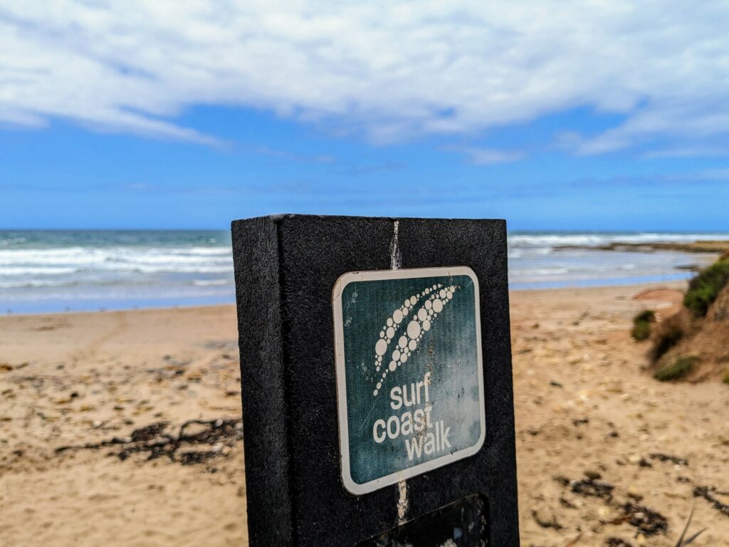
Signage along the way was generally very good, with a distinctive stylised leaf marker at most places that needed one, and larger signs at regular intervals that gave the distance to the next town or point of interest.
The track is well-marked in both directions: most people start at Point Impossible, so that’s the direction I’ve written up the sections below, but I walked the other way because it suited my timings better to have the shorter day first. It really makes little difference which way you go.
Shorter Walks on the Surf Coast
While I chose to tackle the full length end to end, there’s no reason you have to do the same. This is one of the most accessible multi-day paths in the state, running through several towns and with many places to park your car elsewhere along the route, so it’s easy to just walk a small part of it.
Obviously it’s a point-to-point route, so unless you can do a car shuffle, have someone who’s happy to pick you up, or can link up with the infrequent bus service I mentioned earlier, you’ll need to turn around at some stage and return the way you came. That’s far from a hardship, though: the views are epic in both directions!
Below I’ve divided the route I walked into eight sections, each of which is somewhere between two and eight km long. That’s completely arbitrary on my part, but it gives plenty of choice about how far you want to go. Feel free to combine two or more sections, or make up your own: it’s entirely up to you!
There are no bad options, but if I had to pick the best sections to walk, these would probably be my top three:
- Bells Beach to Point Addis (about 8km)
- Point Addis to Anglesea (about 5km)
- Urquhart Bluff to Split Point Lighthouse (about 5km)
Some of the sections can be turned into partial loops by going out or coming back along the beach rather than the marked track. Check the tide times if you plan to do this, since many of the beaches in the area aren’t passable at high tide.
Stage By Stage Guide
I walked the Surf Coast Walk end to end in March 2024 with two friends: below is a guide to each section starting from Point Impossible. Distances are approximate, but should be accurate to within half a kilometre.
1: Point Impossible Car Park to Torquay Beach (6km)
Elevation: Flat
The walk starts at the carpark at the end of Point Impossible Road, a dirt road that branches off just past Torquay’s small aerodrome. Keep an eye out for Tiger Moths: scenic flights operate out of here, and I saw the old biplanes buzzing around several times between here and Bells Beach.
The first three kilometres of walking isn’t the most exciting I’ve ever done, along the Esplanade that at this point is just a dead-straight gravel road, but it got better quickly after that. The first half is pedestrian-only, while the rest is shared with vehicles: keep an eye out, since there were a few drivers who seemed to view the 20kmh signs as a minimum, not a limit.
If the tides allow, there’s also the option of walking along the sand here instead. Note, though, that Point Impossible is a designated nudist beach, so the views may not be quite what you’re expecting!
Either way, you’ll end up at Whites Beach and then Fishermans Beach soon enough, a quieter, more local alternative to the main Torquay town beach a little further ahead. Check out the human-powered sundial as you pass it: not only is it an unusual way to tell the time, but the mosaic design is really lovely.
This section ends at the Torquay foreshore, which has a wide range of cafes and restaurants along the Esplanade. If you’re in need of refreshment, check out Pond Cafe for coffee and a delicious brunch menu (I always seem to end up there whenever I’m in town), or Fishos for great fish and chips.
2: Torquay Beach to Bird Rock (5km)
Elevation: Mostly flat
You’ll start with a walk along the length of the Torquay Promenade, where you’ll often find markets in full swing at the weekend. Stop to check out the Inverlochy Figurehead along the way, a sculpture made from a dead cypress tree. It has an interesting backstory, described on the plaque alongside.
Continue on past Torquay’s beaches: after passing Point Danger, you can either follow the path as marked or do what I did and drop down to the concrete walkway just below it. This is likely to be a busy spot on a hot summer day, with hundreds of people stretched out on the sand or splashing around in the water.
A raised, winding boardwalk crosses Spring Creek just before it empties into the ocean; you’ll need to use it at high tide, but can usually cross on the sand at other times. There was no water there as I passed, about halfway between the low and high tide times.
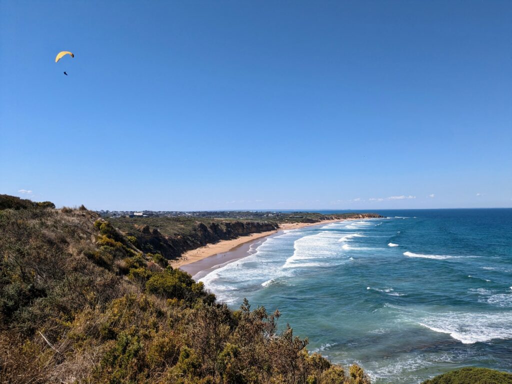
From here, the route meanders along the clifftop, and several viewpoints have been built along the path. It’s not hard to see why: there are fantastic views the whole way along, both back towards Torquay and onward to the Jan Juc coastline. It’s not uncommon to see people paragliding around here, catching the thermals that hit the steep cliffs nearby.
After passing Jan Juc beach, this section ends at Bird Rock, where I took the photo above. From here, it’s only a minute’s walk back to the road, and a minute further to the excellent Swell Foods cafe. Shoutout to the falafel wrap.
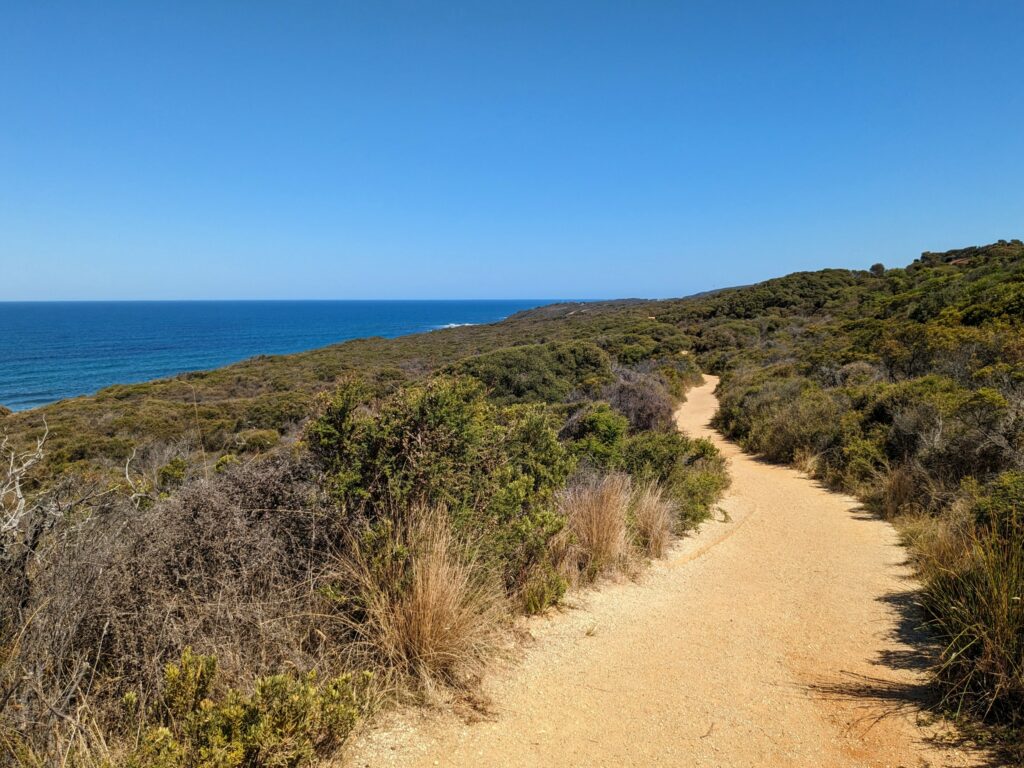
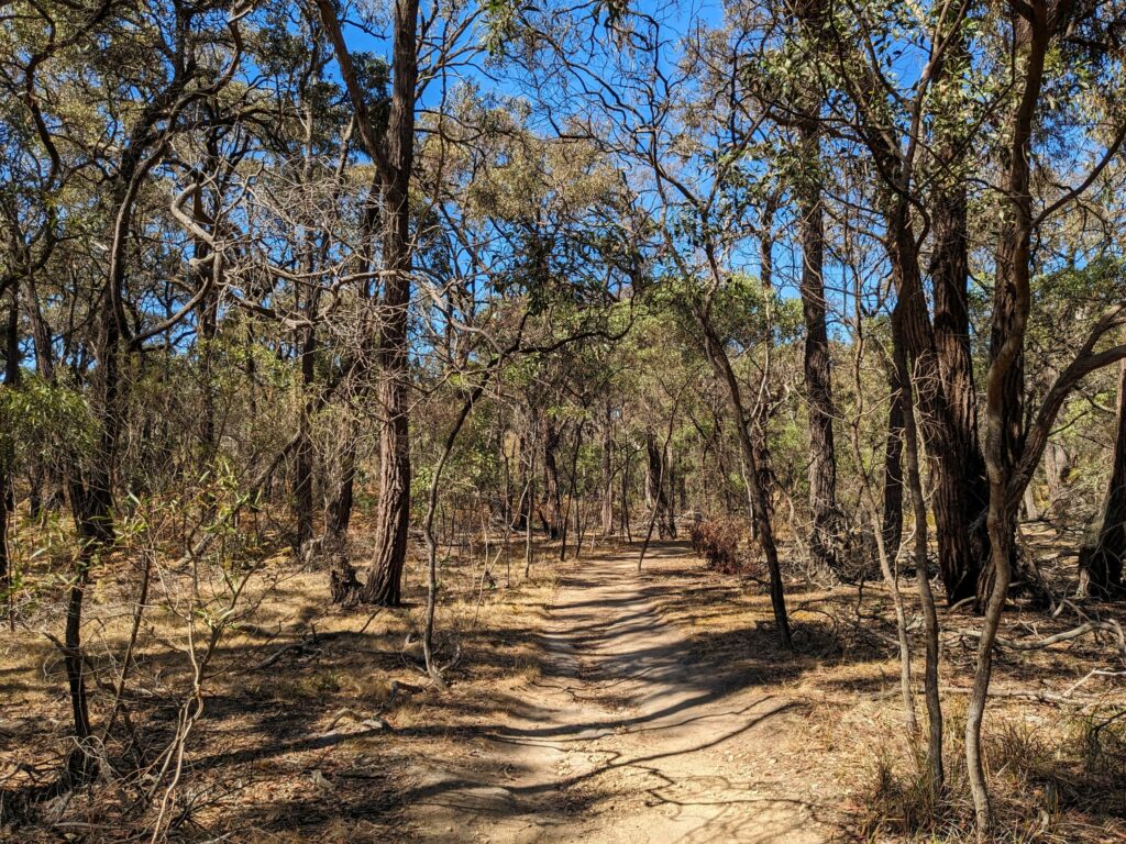
3: Bird Rock to Bells Beach (3.5km)
Elevation: Some hills and steps
The next, relatively short section is very popular with day walkers, and I saw a bunch of people out for a stroll, often with kids or dogs in tow. Speaking of dogs, they’re allowed on the entire trail as long as they’re on a leash. Off-leash rules vary a lot based on where you are and when you’re there: the Surf Coast Council has a page and PDF map with all the details.
Most of this part looks a lot like my photo above, with a well-formed trail that cuts through the scrub at the top of the cliff. It’s pretty easy walking, with some small climbs and descents to get up onto the ridge after Jan Juc and back down again at Bells Beach, but otherwise largely flat.
The path goes past several carparks at Bells Beach, which shows just how popular it is throughout the year, but especially during the Rip Curl Pro surfing event that’s held every Easter. Setup was in full swing as I passed in mid March, a couple of weeks before the competition kicked off, and a few people were getting some practice in out in the waves.
Steps lead down to the beach itself: that’s where this section stops, but if you’re carrying on, you’ll only be on the sand for about ten seconds before heading back up the other side.
4: Bells Beach to Point Addis (8km)
Elevation: Steep hills and steps
Here’s where we hit one of my favourite parts of the entire walk. It’s one of the more diverse sections, with exceptional coastal views at both ends, and a long inland trail in the middle that runs through the forests of the Ironbark Basin.
There were a few people around at either end, but hardly anybody else the rest of the way. That’s probably at least part of the reason I saw two echidnas on this section, and none anywhere else! They were both just busily doing echidna things, snuffling around near the side of the path.
After leaving Bells Beach behind, it’s time for the steepest climb of the walk as you pass lovely Southside Beach and head up the hill and into the forest. We’re not exactly talking Everest here, but it’s about 100m of elevation over 2km, so you’ll notice it. Luckily the surroundings provide more than enough distraction!
There’s plenty of time to catch your breath at the top, though: once you’re up there, it’s an easy, flat path for about 1.5km. There are a couple of alternate routes to explore if you feel like it: a short nature trail that splits off and rejoins the main track, and a path that detours via the old Jarosite mine. They both add a little extra distance, but there’s not much in it in either case.
Whichever route you take, the track starts to drop steeply as it turns back towards the coast, and you quickly lose almost all of the height you gained before climbing straight back up again to arguably the best viewpoint on the trail. It’s very slightly off the main path as you’re approaching Point Addis, but only by about 20m.
At this stage you’re only about 1.5km from the Point Addis carpark that marks the end of this section: the track drops down to it fairly steeply. The carpark is quite large, and there’s also parking along the sides of Point Addis Road that leads up to it, so it’s a good place to leave a car. There are toilets about halfway along the road as well if you need them.
There are several viewpoints connected by a boardwalk here: they’re all a bit different, with dramatic views over the ocean and nearby beaches. It’s a good place to relax for a few minutes after all the climbing and descending of the last hour or two!
Note that at low tide it’s also possible to walk along the beach the whole way from Southside to Point Addis. This cuts out quite a bit of distance and all of the elevation change, and is also a good way of turning this section into a loop. This route, with entry and exit points, is marked on that AllTrails map I mentioned.
Feel free to do it if you prefer sand and ocean to forests and viewpoints, but definitely check the tide times before you set out: there’s not really anywhere to get off the beach along the way. Stay close to the waterline if you do, as rockfalls from the cliffs are quite common, and note that Southside is another clothes-optional beach.
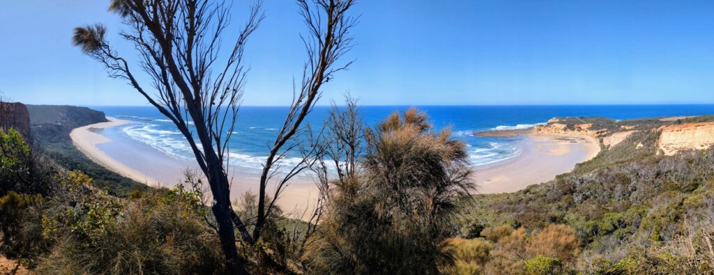
5: Point Addis to Anglesea (7.5km)
Elevation: Some steep hills and steps
Another one of my favourite sections, you immediately drop down from the Point Addis viewpoint onto the beach below. This is one of the places where the official track runs along the sand for about a kilometre, and it’s not hard to see why: not only is it accessible even at high tide, but it’s beautiful and sees very few visitors, even on a perfect blue-sky day.
At the other end, a large wooden sign saying “Walking Tk” points up and away from the water. It’s a short but steepish climb to the top of the cliff, where there’s a great viewpoint looking back over the beach you’ve just walked along. From here, the track heads slightly inland as it passes above Eumeralla Beach.
While it stayed close to the coast, the path didn’t return to the beach again until I got to Anglesea. Instead, it meandered through a lovely stretch of forest for a while before dropping steeply down to a grassy heath that runs almost all the way into town. This is apparently a great spot to see kangaroos and wallabies: it was the wrong time of day when I was there, but I did see (and hear) plenty of birdlife.
You’ll know you’re just about there when you hit a section of boardwalk that crosses some marshy grassland; you can see houses on the hills that rise above the main part of Anglesea town. There are several places you can branch off if you want to, but since I was heading into the centre of town, I just stayed on the path. It turns 90 degrees to run alongside the river, past the main strip of restaurants, and over the bridge.
If you’re staying the night at the Great Ocean Road Resort like I did, it’s on your right just after you’ve crossed the bridge. You’ll pass the Anglesea Pub first, however, if you happen to be in dire need of a drink first. Not that I’d know anything about that.
6: Anglesea to Urquhart Bluff (7.5km)
Elevation: Mostly flat, with steps to and from the beach
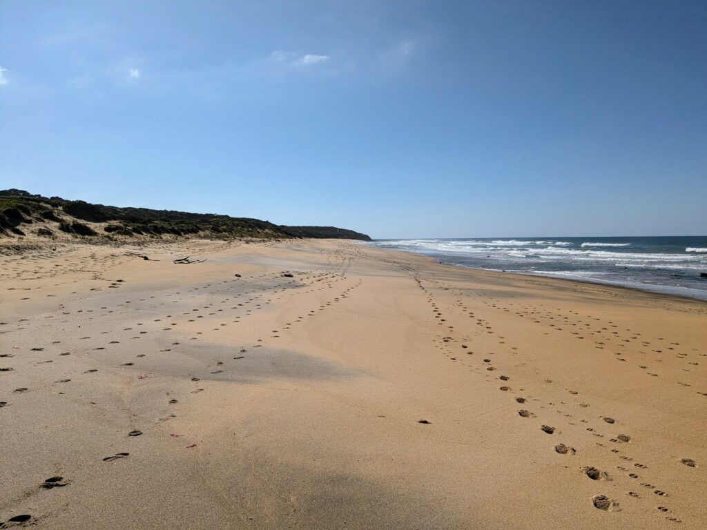
If you like walking on deserted beaches, you’re in for a treat with this section: there’s plenty of it! Before that starts, though, the route leads along the river and out of town alongside the Great Ocean Road: there are a few cafes and restaurants nearby if you’re starting your day, or didn’t pick something up elsewhere in Anglesea.
Before long the road heads inland, but the track doesn’t: instead, it follows the coast to Point Roadknight, with a few great viewpoints to check out including the one that looks back toward Anglesea and over Soapy Rock. There’s a reason it’s called that, especially when wet!
Just on the other side of the point, the trail drops down to the beach. This part around the headland is generally accessible unless the tide is very high, but if there’s an issue, just keep going along the road a bit further: there are three other sets of steps you can use instead.
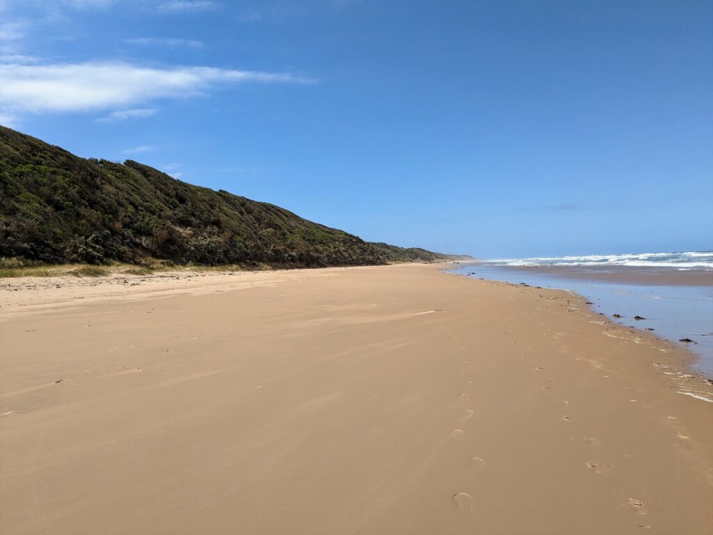
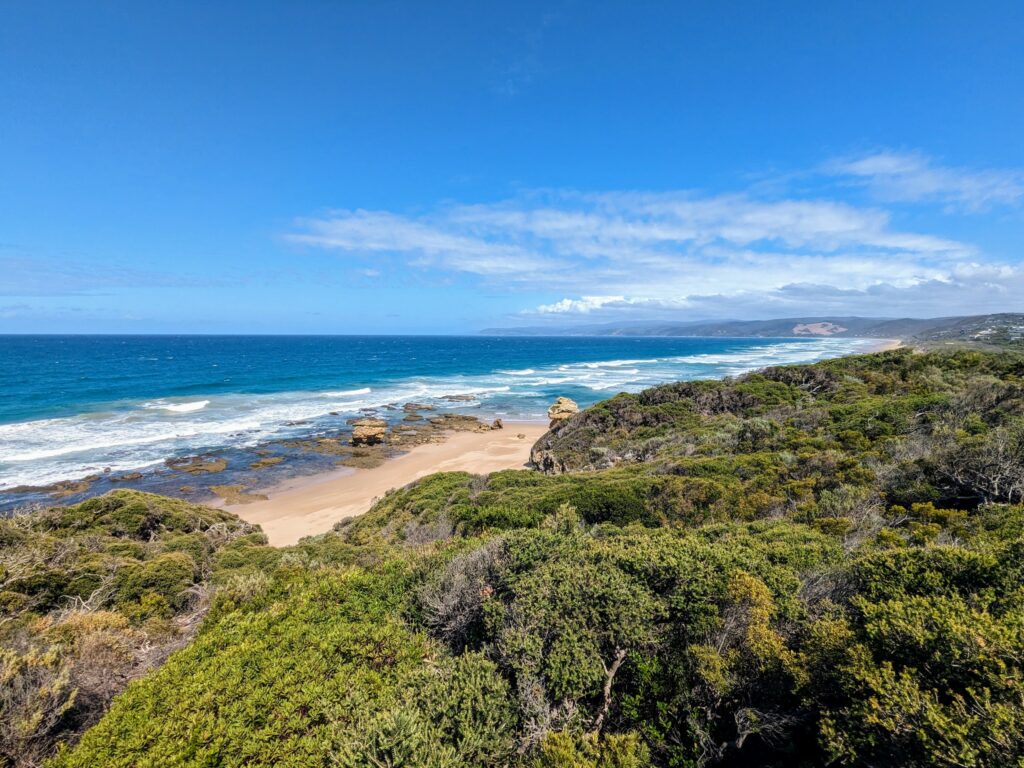
Wherever you start, expect a long, flat stroll. It’s a solid four kilometres from here along Guvvos Beach and all the way to Urquhart Bluff: it’s stunning and you’re unlikely to see (m)any other people until you get to the end, but expect to put in a bit of effort if you’re walking into the wind!
This section ends at the western end of the beach, where you climb up to the Urquhart Bluff Lookout. There’s an information board there with plenty of details about this section of the Great Ocean Road, along with spectacular views of that stretch of sand you just walked along.
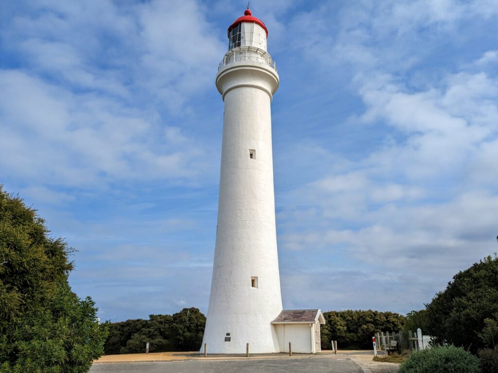
7: Urquhart Bluff to Split Point Lighthouse (6km)
Elevation: some minor hills and occasional steep steps
I really liked this part of the walk: it was surprisingly diverse for such a short distance, with everything from shaded forest to quiet beaches, dramatic viewpoints to, of course, the towering lighthouse at the end.
The section starts at the lookout I mentioned above, where the trail immediately heads away from the cliffs and into the forest. There are occasional glimpses of the ocean and beaches through the tree, but for the most part, there’s fairly thick tree cover that offers welcome shade on sunny days–there isn’t much of it on the sections before and after.
There’s a wooden table and benches shortly after Urquhart Bluff if you need somewhere to have lunch (I did), before the track bends back towards the coast and steps lead down to Sunnymead Beach. It’s a lovely quiet spot that’s only ever had dog walkers on it whenever I’ve been here in the past, and so it was this time around as well.
After a quick stomp along the sand (stay clear of the cliffs, since they’re eroding fast and prone to rockfall), there’s a five-minute climb back up the other side to the carpark at the end of Boundary Road. It’s not long after this that the lighthouse starts to come into view: unsurprisingly, it’s designed to be seen for miles around!
It’s quite the iconic landmark around these parts, not only because it was the star of a children’s TV show in the 1990s, but because it had been keeping ships off the rocks here for a hundred years beforehand.
Before you get to it, though, there’s about three kilometres of clifftop trail to enjoy, running parallel to Aireys Inlet through bushland. This bit is popular with dog walkers and other locals, and you’ve got epic views of the ocean the whole way.
Once you arrive at the lighthouse itself, expect to find quite a few people milling around: many international visitors include it on their Great Ocean Road itinerary, and you can go up to the top at certain times of day if you’re happy to pay ten bucks.
There’s a boardwalk with several viewpoints that look out over Eagle Rock and the surrounding ocean, and a cafe just down the road from the lighthouse that I had a coffee at once and probably wouldn’t choose to do so a second time.
8: Split Point Lighthouse to Fairhaven (2km)
Elevation: flat except for getting to/from the lighthouse
Once you’re done at the lighthouse, follow the path down the hill and around the back of Painkalac Creek: there’s a small but lovely beach here as well, where the creek trickles into the ocean. It’s under 2km from here to the end of the trail, and paved the whole way.
The trail largely runs along the side of the Great Ocean Road here, one of the few places it does for any real distance. Even so, it ducks away from it wherever it can, so there’s little in the way of road noise to ruin the vibe as you approach the finish line.
Even so, if you fancy one last beach walk to cap things off, it’s definitely an option. The trail naturally curves towards Fairhaven Beach anyway, so once you’re past the creek, just head down to the beach on one of the side trails and enjoy your last few minutes with sand under your boots.
All too soon you’ll be at the Fairhaven Surf Lifesaving Club, which makes the official end point of the Surf Coast Walk. The club itself is only open in the evenings, but there’s a kiosk outside that’s open during the day (or at least was when I was there) and does great toasties and even better coffee.
What better way to celebrate the end of a 44km stroll along some of the most beautiful coastline in Victoria?
Got any questions about the Surf Coast Walk? Feel free to leave them in the comments and I’ll do my best to help!
All images copyright Everything Victoria